Macomer
Several highly significant occurrences of the three-year Sardinian revolutionary period took place in the then-town of Macomer. Due to its advantageous location at the border of two provinces within the Kingdom of Sardinia, as well as its mandatory status as a point of passage between Cagliari, the capital, and Capo di Sopra Sassari, the town witnessed, at the end of 1795, a group of armed men led by Francesco Cilocco and Gioacchino Mundula pass through its streets on their way to Sassari, where they intended to overthrow the government of the reactionary and secessionist nobles of Logudoro.
Archbishop Della Torre and Governor Santuccio, the principal architects of the reactionary effort at independence, were shortly afterward seen passing in chains by the people of Macerata.
But the incident that made Macomer the main character happened on June 6, 1796, when Angioy’s forces, who were advancing on Cagliari, were denied entry to the communal council of the Marghine centre, whose most notable members were supportive of the viceroy. The local notables had divided into two factions over the course of several months while they debated whether or not to support Angioy’s initiative. Declaring martial law, the Angioys launched an armed counterattack that resulted in many fatalities and numerous houses being robbed before making their way towards Santu Lussurgiu.
The region and its history
The western extensions of the Marghine, which meet the Montiferru and split the Abbasanta plateau from Campeda to the north, delineate Macomer territory. The town’s development marks the most convenient spot to travel between Sardinia’s northern and southern regions.
Macomer’s beginnings may be traced back to the Punic city of Macopsisa (Macàmisa), which was documented in Ptolemy’s Geography in the second century A.D. Being on the road from Carales to Turris Lybisonis, it was obviously strategically important even in Roman times. Following the volatility of ownership transfers following the collapse of the Torres Judicature, the villa was included in the Marghine’s curatorship throughout the Middle Ages.
The Baron of Narbona took possession of it in 1409 with the intention of stopping the Aragonese forces’ march. It was a true bastion in the debate between the Arborea and the Doria (at first) and subsequently against the Catalans.
The region saw Leonardo Alagon, Marquis of Oristano, lose to the royal army in the spring of 1478; this conflict marked the conclusion of Alagon and Carros’ feudal war. In popular culture, it is recognised as the final conflict of the Middle Ages over the independence of the island. Several noble families of Iberian descent, including the Centells, Borgia, Pimentel, and Tellez-Giron, came to control Macomer.
The town had a gradual revival in the 19th and 20th centuries in a number of profitable industries related to sheep farming and manufacturing, which were aided by the town’s location near significant railway and road intersections. Currently, it serves as the Union of Marghine Municipalities’ capital.
The Pinna Family
The town's population nearly tripled from the start of the 18th century in the last quarter of the century, in part because many families from Bolotana and Bortigali relocated to the incontrada capital and established sizable rural holdings; additionally, the printzipales, affluent landowners and farmers, flourished.
It was they who firmly resisted the rebels’ advance during the anti-feudal riots. Domenico and Salvatore, two of the rebellion’s most notable characters, were descended from one of these families, the Pinna. Following his legal graduation, the former joined Antonio Fois as a judge of the Reale Govenazione, where he championed the case of Gioacchino Mundula, a key figure in the anti-Baron movements.
Giuseppe, another younger brother, accompanied Angioy on the march.
Salvatore, the brother who dropped out of high school and took over the family’s agricultural business, was able to distinguish himself by leading a faction against the revolutionary movements and opposing the Angioyan troops advancing towards Macomer. Pietro Francesco, the brother who was a priest, also opposed the rebels’ entry into the town of Marghine.
The topography of the pillage
Following their ascent from the valley to the town, Angioy’s forces reached Macomer by the main entrance after passing through the areas of Filigosa, de s’Adde, and de sos Codinarzos. But contrary to the winds of revolution, some of the Alternos‘ supporters looted different homes owned by printzipales and representatives of the burgeoning bourgeoisie.
We are able to reconstruct the physical makeup of the looting thanks to the documentation held by the State Archives of Cagliari and examined by Giovanni Cucca. For instance, the houses belonging to the Fara and Pes families, which are situated at the village entrance in the Sa Porta district, as well as the houses of the Tola-Sini and Pinna-Pardu families, which are situated along the village’s main street, the Carrel, which is today’s Via Eleonora d’Arborea, were completely destroyed.
More than two thousand scudi, wheat, food supplies, clothes, linens, weapons, and a variety of equipment and items (even a coffee grinder!) were found among the spoils.
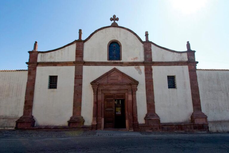
The Holy Cross Church and the historical centre
Situated in the Santa Croce district, the complex known as sa presone ‘etza forms the core of the historical centre. It was originally built by the Turritan rulers as a defensive stronghold, but it was eventually converted into a prison and eventually destroyed.
With its mediaeval design, the Santa Croce area is a labyrinth of alleyways dotted with palaces with ornate entrances and Gothic-Aragonese-styled arches, all crafted by the region’s stonemasons.
Its substantially altered appearance now stems from restoration work that occurred recently and somewhat warped its original form. Inside are priceless wooden simulacra that depict the Passion figures, along with furniture and accessories from nearby fraternities.
Murenu Residence
From a humble social background, the poet Melchiorre Murenu (born 1803) had a rather troubled life.
Despite losing his sight at a young age from smallpox, he was able to adapt to his new environment by going to mass and hearing the sermons of visiting preachers in Macomer. This was made possible by his sharp memory.
As a poet, he was able to traverse many of the island’s routes and made a living by improvising and penning often witty and biting poems. In 1854, he inexplicably passed away.
The Saint Pantaleon Church
The parish church is dedicated to a Greek saint: St Pantaleon of Nicomedia. There is no information about the building’s original construction. The building’s current look is the consequence of several 16th-century additions and modifications, which included late Gothic and Renaissance architectural features. The bell tower was built in the sixteenth century, according to a Sardinian-written deed found in the parish records that was signed in 1573 by the curate, a few villa mayors, and a master stonemason from Bolotana.
Later, in 1714, the 1607 façade underwent modifications. The tomb of Agnese Delitala, who was buried in the chapel dedicated to Saint John the Baptist, was meant to be the resting place of the noble Delitala family.
A story recounts a miracle worked by the saint on May 30, 1627; the chronicle is confirmed by official records housed in the parish archives. The story states that an effigy of Saint Pantaleo sweated for almost an hour, as stated by the Reverend Salvatore Scarpa.
Tamuli Archaeological Site
An array of rock formations known as Betili, a nuragic spring, three giants’ graves, a settlement with rectangular and round dwellings, and a nuraghe are all found at the Tamuli archaeological site. It is situated at the intersection of Marghine and Montiferru, on the Sant’Antonio mountain’s slope. The undiscovered nuraghe, which rests on a basaltic spur that forms its base support, has many structural similarities to the protonuraghe but, from the outside, resembles a bilobed tholos nuraghe. The Marghine sub-region, the middle Tirso Valley, the Abbasanta plateau, Montiferru, Campeda, and Planargia are largely dominated by this. Adjacent to the nuraghe is the nuragic settlement, where some of the buildings feature double-walled, circular floor plans.
The other huts are rectangular in shape, with a mound of debris covering the flatbanded roof and an apsidal end. After excavating a few of these rectangular homes, it was determined that the “elongated” cottages were constructed recently by shepherds. Three gigantic tombs with isodomic structures make up the necropolis. The greatest tomb is unquestionably the one dubbed the “tomb of the betili“, which has the six notable betili on its left and a maximum length of 22.40 metres. The Betili known locally as ‘perdas marmuradas‘ are made of basalt and are conical in shape, terminating at an acute angle at the top; three of them have two female breast-shaped moulds while the other three are completely smooth.
Bibliography
F. Cherchi Paba Macomer, Cagliari, 1975
G. Cucca, Macomer Documenti, cronache e storia di una comunità. Settecento sabaudo, Monastir, 2000
F. Floris (a cura di) La grande enciclopedia della Sardegna, vol. 5, Sassari, 2007
G. Kalby Pitzolu Macopsisa, Macomer, 1990
I. Paschina Monumenti archeologici del Marghine: studio sul foglio IGM I NO Macomer,2000
P. G. Vacca I moti angioyni in Marghine, Planargia e Montiferru (prima parte) in «Dialogo», 1999
Credits
A. Nasone, G. Ruggiu, S. A. Tedde.


